2016-02-08
Get elevation data
You can get most geodata on OpenStreetMap. But there is one type of data you do not get there: elevation data.
SRTM
From the wikipedia article
The Shuttle Radar Topography Mission (SRTM) is an international research effort that obtained digital elevation models on a near-global scale from 56° S to 60° N. (...) The elevation models are arranged into tiles, each covering one degree of latitude and one degree of longitude, named according to their south western corners. (...) They can be downloaded freely over the Internet, and their file format (.hgt) is widely supported.
Where can I get some?
After a quick internet search I found somewhere to get said .hgt files: viewfinderpanorama.org. I am sure there are other sources but this is what we are looking for.
As an example I will get the rock of Gibraltar with the following bounding box:
{
    minLongitude: -5.376434,
    minLatitude: 36.10626,
    maxLongitude: -5.324249,
    maxLatitude: 36.160885
}
The tile we are looking for is N36W006.hgt.
Extract the data
I tried opening the file in a text editor. Turns out it is not in a human readable format. But there is a package that reads most geodata, GDAL. If you do GIS on your computer, chances are you already have it installed as it comes as a dependency to a lot of mapping software.
GDAL
Check if you have it by opening a terminal window:
$ ogrinfo
If you get something like below, you have it.
Usage: ogrinfo [--help-general] [-ro] [-q] [-where restricted_where]
               [-spat xmin ymin xmax ymax] [-geomfield field] [-fid fid]
               [-sql statement] [-dialect sql_dialect] [-al] [-so] [-fields={YES/NO}]
               [-geom={YES/NO/SUMMARY}][--formats]
               datasource_name [layer [layer ...]]

FAILURE: No datasource specified.
Otherwise, see install instructions here.
Crop the area we want
The first step is to crop the .hgt file to the area we need with gdalwarp.
The pattern looks like this:
gdalwarp -te <x_min> <y_min> <x_max> <y_max> source.file destination.file
So for gibraltar we do:
gdalwarp -te -5.376434 36.10626 -5.324249 36.160885 N36W006.hgt gibraltar.hgt
Our bounding box fits into a single .hgt file. If it had been on several files, we would have added all source files, like this:
gdalwarp -te <x_min> <y_min> <x_max> <y_max> source1.file source2.file source3.file destination.file
Convert to GeoTIFF
Now that we have gibraltar.hgt, let's convert it to a GeoTIFF, a georeferenced image file.
First we need to specify the color scale we want by creating a file called relief.clr:
100% 255:255:255
0%   0:0:0
nv   0:0:0
This is a black and white color scale.
Then we convert it using gdaldem:
gdaldem color-relief -of GTiff gibraltar.hgt relief.clr gibraltar.tiff
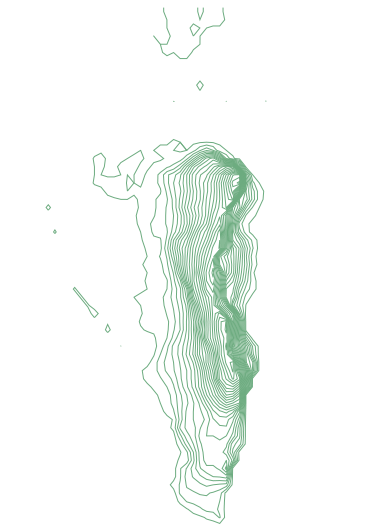
We get a picture that looks like this:

Convert to vector data
We have a raster file but want to convert it to a vector format. We will use gdal_contour specifing the following options:
the height interval in meters.
what to do with void pixels (see the explanation here)
the output format (defaults to shapefile)
the name of the elevation property
The command looks like this:
gdal_contour -i 10 -snodata 32767 -f "GeoJSON" -a height gibraltar.tiff gibraltar.json
We have a GeoJSON file (a human readable vector data format) called gibraltar.json.